News
Will Hurricane Joaquin Be Anything Like Sandy?
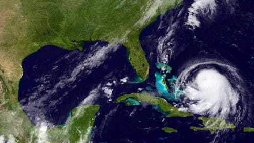
On Wednesday, tropical storm Joaquin, a storm that had been developing in the Atlantic Ocean, was upgraded to a Category 1 hurricane. It had been labeled a Category 3 as of Thursday morning, and Gov. Chris Christie declared a state of emergency in New Jersey. The projected path and expected wind-speeds of for the latest storm in the Atlantic has some comparing Hurricane Joaquin to Hurricane Sandy, the storm that caused significant damage to Connecticut, New Jersey, and New York, as well as the Bahamas. (Update: Hurricane Joaquin strengthened to a Category 4 hurricane on Thursday afternoon.)
Currently, Joaquin's maximum sustained wind-speeds are around 120 miles per hour. Meteorologists have predicted that Hurricane Joaquin will reach Category 4 levels by the weekend, which is one category higher than Sandy reached when it made landfall on the east cost in 2012. Given the similarities between Joaquin and Sandy that meteorologists have noted so far, many are wondering whether or not Hurricane Joaquin could cause as much damage to the eastern coast of the U.S. as Sandy did.
According to Weather Underground, the center of the storm is located approximately 65 miles away from San Salvador in the central Bahamas, and is moving northwest. Effects in the Bahamas are expected to be life-threatening in some areas, and Weather Underground has predicted that Joaquin could begin heavily affecting the East Coast this weekend or early next week.

As CNN reported Thursday, it's understandable for East Coast residents to be nervous about the possible impacts of Hurricane Joaquin, given how devastating Sandy was for some communities a mere three years ago. Because hurricanes are difficult to predict, there is no saying for sure what might happen with Joaquin and whether or not it will blow over before getting to the East Coast, or if it could cause a disaster situation. Unpredictability notwithstanding, computer models are still being used to track Joaquin and attempt to predict its progress, and currently it looks as though it could hit very close to where Sandy did.
The Weather Channel reported on Thursday morning that, while Joaquin suddenly intensified from a Category 1 to a Category 3 on Wednesday evening, it is expected to weaken somewhat before possibly hitting the East Coast. Further, Joaquin has a wind field much smaller than Sandy's, and the primary concern for Joaquin in the East Coast will be heavy rain fall, as some models show Joaquin staying far enough offshore that a storm surge will not occur.

But due to the highly unpredictable nature of all hurricanes, no meteorologist is certain about what will happen with Joaquin and how similar it will ultimately be to Hurricane Sandy. Warnings are in effect for the Bahamas, where the threat of damage due to Joaquin is currently the most imminent (the hurricane is expected to remain stationary in the Bahamas for about two days, according to The Weather Channel). The National Hurricane Center will continue to post advisories as Joaquin continues on its path.
