News
9 Frightening Weather Maps of Hurricane Hermine
As news continues to circulate about Hurricane Hermine, which was initially dubbed a tropical storm until it picked up on Thursday afternoon, the maps tracking the storm are utterly terrifying. And if you want to catch a glimpse of mother nature in her less-than-calm state, there are some amazing weather maps of Hurricane Hermine available so that you, too, can track the storm as it approaches.Earlier on Thursday afternoon, data from an Air Force hurricane hunter plane recorded that tropical storm Hermine was churning at about 75 miles per hour, according to the Miami-based National Hurricane Center. And as northwestern Florida and southwestern Georgia brace for what could be a very powerful storm, all eyes are on the weather maps and models that are tracking the hurricane. Both Florida and Georgia have declared states of emergency for many regions in both states, and mandatory evacuations are in effect for residents living in low-lying areas. The storm is likely to bring surges to many of the coastal areas in Florida as well, which could result in severe flooding of 1 to 5 feet in some areas. Hurricane Hermine, which is the eighth storm of the season, is three weeks ahead of the average date for the storm.
Some models shown below, which are also being shared via social media, show Hurricane Hermine strengthening as it makes it way through the Gulf of Mexico.
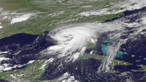
And there is also this breathtaking world view of the storm, as shared by Mashable.com.
As the panhandle and Big Bend regions of Florida prepare for the hurricane, residents are stocking up on necessary items, sandbagging homes, and if necessary, relocating. Tallahassee, Florida, which has not been directly hit by a Hurricane in more than 30 years, endured terrible devastation with Hurricane Kate in 1985, and could see similar damage in the amount of flooding and downed power lines and trees from Hurricane Hermine.
Hermine is expected to make landfall near Apalachicola, Florida, which is at an optimal low tide, but the city has been hit hard before. Hurricane Dennis in 2005 and Hurricane Elena in 1985 caused major flooding and damage to the region, and some forecasters are fearing the area could experience similar destruction. However, another area further down the coast, Cedar Bay, is expected to be hit by Hermine when it's water level is 3.2 feet higher than low tide. As the storm makes its way closer to the state, anything could change, making it that much more important to remain updated, whether it's via these weather maps or weather reports.
