News
Did The Alps Play A Role In Germanwings Crash?
A Germanwings Airbus 320 carrying 150 passengers and crew crashed Tuesday in southern France after reportedly making a quick yet controlled descent en route to Düsseldorf, Germany. According to French authorities, Flight 4U9525 went down in the French Alps near Digne, a commune in the Alpes-de-Haute-Provence department. The plane had just crossed a northern patch of the Mediterranean Sea, and was only about 35 minutes into its flight after departing from Barcelona when it began to descend.
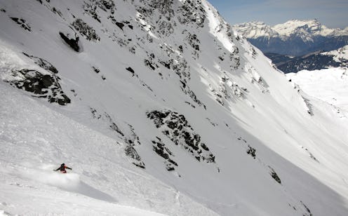
According to live flight tracking system Flightrader24, Flight 4U9525 was last seen flying at 6,800 feet — a dangerous altitude, considering that the area has peaks well over 10,000 feet. In fact, the suspected location of the crash is at least 6,000 feet above sea level, CNN reports. That means the plane may have been descending right into the rugged terrain of the French Alps, where there's hardly any open land.
Flightradar24, as well as raw data collected from tracking system Plane Finder, reveal that Flight 4U9525 descended from 38,000 feet to around 24,000 feet in just six minutes. Then, the Airbus descended from 24,000 feet to around 6,800 in a matter of minutes without a significant change in speed, according to the plane's radar. For the last couple minutes of the flight, Flight 4U9525 was likely flying among the mountains given the elevation of the region and the plane's low altitude.
You can see the flight's dangerous descent in Flightradar24's recorded data. The plane began its quick yet seemingly smooth descent shortly after reaching a cruising altitude at 38,000.


For a visualization of what the pilots of Flight 4U9525 were dealing with when the plane began to dip to altitudes barely above the height of the French Alps' tallest peaks, Plane Finder has released live images of the area, via Sky News:
Helicopters, as well as planes dispatched by the French Air Force, are currently circling the area of the suspected crash site. As you can see from some of these live images, the terrain is not only steep but also jagged and rough, with very little flat land.
Close ups of the radar also show that the terrain is not very accommodating to low-flying jetliners, not only because of the high peaks and elevation, but also due to the lack of open land in case of an emergency.
