News
What Does The San Andreas Fault Look Like?
San Andreas is set to hit theaters on May 28. The movie, starring Dwayne Johnson and Carla Gugino, depicts the major California earthquake that seismologists have been loosely predicting finally hitting the golden state and, if its poster is any indication, practically ripping California in half. The images of what the San Andreas fault looks like evoke a ubiquitous California earthquake myth that if and when the big earthquake hits, it will either push the state into the ocean or divide it completely.
Despite running a good 810 miles, the San Andreas fault even at its shakiest wouldn't move enough earth to split the state. San Andreas is a strike-slip or transform fault whose plates move in the opposite direction at a rate of a few feet at the absolute most. The formation of the San Andreas fault dates back 28 million years ago, and the fault has been growing ever since. According to SanAndreasFault.org, the rate of growth is so slow that it would take an additional 25.3 million years "for the state to be sheared and twisted beyond all recognition."
What makes the San Andreas fault fascinating and the landscape of California so diverse is the fact that the fault line occurs on land rather than underwater. The gorgeous hues and jagged edges of the Vasquez Rocks, the naturally occurring oasis in Thousand Palms, and the tranquil Tomales Bay in Marin County can all thank the San Andreas fault for pushing them into existence. Research organization Thule Scientific's website offers an interactive Google Map of the massive fault line, which extends from the King Range National Conservation area in northern California to the Salton Sea:

Below, the Vasquez Rocks are seen along the San Andreas Fault:

The Thousand Palms Oasis shows the San Andreas fault zigzagging between palm trees:

The San Andreas Fault cuts right in the middle of Tomales Bay:

SanAndreasFault.org also offers aerial photos depicting the many segments of the San Andreas fault, which includes images of the Banning fault and other related faults that dot the state. Three different fault zones make up the San Andreas and at least a dozen other faults run throughout, which is highly unusual.

Palm trees dot the southern section of the San Andreas Fault just before the Salton Sea:

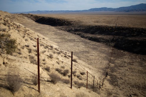
A southern portion of the San Andreas Fault is seen snaking through the Carrizo Plain:

A view of the San Andreas Fault from central California to the beginning of the Carrizo Plain:

San Andreas promises to be an action-packed movie spanning the major cities of California, Los Angeles and San Francisco. For all its pyrotechnic visuals and CGI effects, it can only come so close to the actual fault line. There is a lot to explore across the San Andreas fault and just as much adventure say, hiking the Pacific Crest Trail, which spans a large portion of the fault, as there is on the big screen.
Images: Getty (1), SanAndreasFault.org (), WikiCommons (1), Flickr/bdearth (1), Flickr/familyclan (1)
