With one hurricane after the other, this year's stormy Atlantic season has been a particularly intense one, especially for the Caribbean islands. One of the islands, Dominica, has endured "mind boggling" amounts of destruction according to its prime minister after Hurricane Maria hit the region. According to weather experts, Hurricane Maria carried winds at a monstrous 160 mph, resulting in major damage inflicted on residential buildings. Over and over again, radar and satellite images of Hurricane Maria depicted a jaw-dropping Category 5 storm which formed only a few brutally short days after the equally terrifying Hurricane Irma.
Currently, The National Hurricane Center has classified Maria as a Category 5 storm which is presently headed toward the Virgin Islands and Puerto Rico. The hurricane is expected to hit both regions on Wednesday. Puerto Rico Governor Ricardo Rossello noted Maria's remarkable strength and said, "No generation has seen a hurricane like this since San Felipe II in 1928. This is an unprecedented atmospheric system."
So far, Hurricane Maria has resulted in one death in Guadeloupe, according to officials, while two people have been reported to be missing after a boat sank near the state's shores. Officials believe that 40 percent of the population is currently without electric power.
Here are several shocking radar images of Hurricane Maria, the latest development of this year's Atlantic hurricane season.
1. Eye of Maria
Hurricane Maria has been labelled the strongest hurricane to hit Dominica.
2. Maria From Space
Satellite images of Maria showed the hurricane causing chaos in the Virgin Islands and Puerto Rico.
3. Maria Via San Juan Radar
San Juan's radar highlighted Maria's eye and showed how powerful the hurricane is.
4. Maria's Compact Eye
A Weather Channel report on Maria is being periodically updated with developments on the hurricane. Currently, it shows the storm lingering around Guadeloupe, heading toward Puerto Rico as well as the Dominican Republic.
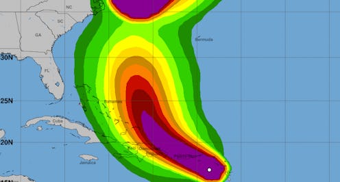
5. Radar Intensity
Images from the San Juan radar showed the increasing intensity of the hurricane with green depicting as light, yellow for moderate, red for heavy, and purple for extreme. At this moment, the radar shows an amalgam of light, moderate, heavy impact.
6. Infrared Radar For Maria
Hurricane Advisories described Maria as "catastrophic" while The Weather Channel said it could be "life-threatening."
7. Eagle's Eye Look At Maria
A more elevated view of the stunning storm.
8. French Radar
European weather models also took notice of the Category 5 storm.
9. Maria's Rainbands
Infrared imagery of Hurricane Maria gave an idea about the hurricane rainbands as they pummeled the Virgin Islands.
10. Concentric Eyewall
Some meteorologists noted that Maria may possibly have not one but two eyewalls.
11. In Irma's Footsteps
Meteorologists have warned against storm surge and flooding in the wake of the storm.
12. Tracking Maria's Current Path
If you're in the path of Hurricane Maria, you should keep a consistent eye on the developments taking place within the storm by checking these updates from the NHC.
13. Four Panel View of Maria
A four-panel view of Maria consisting of water imagery, vapor imagery, visible trajectory, and infrared visuals.
14. Maria Barreling Forward
From a Category 1 storm to a Category 5 hurricane, Maria has shocked many.
15. Inside Top 10 Strongest Atlantic Hurricanes
Meteorologists believe that Hurricane Maria is one of the top 10 most intense hurricanes in the Atlantic hurricane season. Roberto Garcia of the National Weather Service in San Juan said that Hurricane Maria is "catastrophic in every way." Garcia went on to say, "People have to act, and they have to act now. They can no longer wait for a miracle."
If you or your loved ones are in the potential way of Hurricane Maria, keep yourself updated with the National Hurricane Center's tips, resources, and insight.
