News
24 Hurricane Irma GIFs Showcase The Storm's Mind-Blowing Development
Hurricane Irma rightly has many worried in the mainland United States, particularly Florida. But its path from the Atlantic Ocean, just west of the African Coast, to its current destructive push through the Caribbean is already worth discussing. It's record-setting. Irma has sustained 185 mile-per-hour winds longer than any other Atlantic hurricane in history, and it made landfall at that strength too. These Hurricane Irma GIFs show that huge, destructive power in visual form.
The images on the ground from some of the worst-hit islands are lacking, given that the storm first hit in the middle of the night. On Barbuda, Prime Minister Gaston Browne said that 90 percent of the island's structures and vehicles were destroyed; at least one person died. On Saint Martin, at least six died on the French-administered half of the island. And in Puerto Rico, where the wall of the storm luckily stayed off the coast of the island, nearly 1 million people had lost power. Many areas are also without water.
The damage is set to continue, as Irma moves toward the Dominican Republic and then the Turks and Caicos islands as well as the Bahamas. Not only will there be the crushing winds that have been seen along Irma's path, but the storm surge will also be formidable, up to 20 feet in some areas, according to the National Hurricane Center. To get an idea for how bad the storm can be, consider these GIFs of radar and satellite images. They're truly astounding.
1) This Path Looks Familiar

Some of the earliest predictions were pretty accurate. Irma first made landfall as a Category 5 in the Leeward Islands a bit earlier.
2) Back When Category 1 Was A Worry

The storm started off as a tropical storm off the coast of Africa in the eastern Atlantic Ocean.
3) If Only This Model Had Been Correct

Imagine if Irma had stayed out at sea, not endangering anyone.
4) It Was All Worrying Early On

This GIF might be a little light-hearted given the damage now seen, but it just shows that some were worried from early on.
5) The Danger Quickly Became Clear

It just took days for it to become clear where Irma would head, and how strong she would get.
6) Even If She Was Technically Still On The Small Side

No visual eye here. The storm has grown immensely since then.
7) It Jumped From Tropical Storm To Category 2

It didn't take any time for it to jump up to Category 2.
8) Then It Started To Head West To The Caribbean

It trudged along, gaining power the whole way.
9) Florida Became More Clearly In Irma's Path

The models started to solidify on Florida getting a direct hit.
10) Talk Of The East Coast Getting Hit Grew Too

Even now, though, it is impossible to know which way it will turn after reaching Florida.

12) Strongest Ever By Some Measures

The strongest one still in the Atlantic Ocean ever.
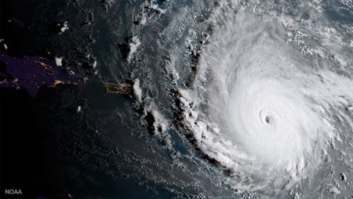
13) The Eye Takes Shape

When it moved up to a Category 5 storm, the eye became visible.
14) Sun Over The Eye

It's even more pronounced with the light of the sun and its shadow.
15) Big Winds & A Huge Surface

The storm was obviously much bigger than the small islands it would run into first.
16) The Eye Goes Straight Across Islands

Some whole islands appear within the eye.
17) There Are Several Direct Hits

But the islands are too small to limit its strength.
18) And Then There Were Three

Irma gets little siblings. Jose's following right behind her, while Katia has formed in the Gulf of Mexico.


21) Luckily Puerto Rico Misses The Worst Of It

The eye stays offshore, a lucky state of affairs given how ill-prepared the infrastructure there was.

23) Now Add Lightning To The Mix

The yellow flashes of the GIF are lightning strikes.
24) And All Of This Data Means

Taking a look at the maps and radar of this huge, record-setting storm is definitely humbling. Just make sure that you take the necessary precautions if you'll be somewhere in its path. If you can evacuate now, you just might want to.
