News
Here's Tropical Storm Florence's Slow Trajectory Across The Carolinas
After a week of waiting, the historic storm arrived Friday. The trajectory of Hurricane Florence has slowed to a crawl since making landfall in North Carolina on Friday.
The National Hurricane Center said Florence, which was downgraded to a tropical storm on Friday, is "moving slowly" west at about 2 mph. The New York Times reported predictions of up to 40 inches of rainfall, with even more expected in certain parts of the Carolinas.
Two parts of North Carolina are expected to beat the area's rainfall record of 24.06 inches from Hurricane Floyd in 1999, according to the Weather Channel. Newport reported 23.75 inches while Morehead City just passed 23 inches — and rain is still falling.
Even greater amounts of rain have been measured in Swansboro, North Carolina. As of Saturday Morning, the Weather Channel reported 30.59 inches of rain in the area.
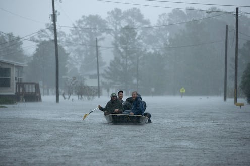
As of Saturday morning, at least five people have died because of Tropical Storm Florence, according to CNN. Another two deaths were reported, but officials have not confirmed if they were storm related, The New York Times reported.
Other effects of the storm have been massive power outages. BuzzFeed News reported that more than 880,000 power outages have been recorded across North and South Carolina.
Radar Shows Its Slow Crawl

The National Hurricane Center said on Saturday morning that Tropical Storm Florence is "crawling westward" through South Carolina. By Sunday the storm is expected to take a turn northwest, according to the Center. The storm is expected to be in the Ohio Valley on Monday.
The storm's reported maximum sustained winds are around 45 mph, according to the Center's morning report.
Because the storm is moving at such a slow pace, it means rainfall is more likely to fall on the same areas for a sustained period of time.
Flooding Potential

Tropical Storm Florence has dumped massive amounts of rainfall on the North Carolina coast and into the state's rivers, worrying state officials. As the storm's relative intensity has lessened (gone from a hurricane to a tropical storm), that doesn't mean the effects of heavy rainfall have dissipated.
The Weather Channel reported rainfall totals of 15 to 25 inches across eastern North Carolina as of Saturday morning. Flash flood emergencies were issued for a number of counties on Saturday morning.
The Crawl North

The storm's major impact will be in North and South Carolina, but this map shows how the storm is expected to travel next week as it moves north over the East Coast. Forecasters estimate the storm's remnants will reach Pennsylvania by Tuesday morning.
The Distinction Between The Storm's Center And Its Bands

There's an important distinction to keep in mind when looking forward with regards to Florence: the storm's center versus the storm's bands. Brad Panovich, chief meteorologist at Charlotte NBC-affiliate WCNC, posted a video to Twitter to untangle the differences. "We don't really care where the center is, we care where the impacts are," Panovich explained, adding that that's where citizens would be seeing heavy rainfall, winds, and possibly tornados.
Because of the storm's turning point, areas around Charlotte are likely to see the heavy rainfall, which could cause flash flooding. "The east and northeast side — where we're going to be — is the worst weather," Panovich said of Charlotte.
