News
This One Video Of Hurricane Irma Bashing Florida Will Really Show You The Power It's Packing
Hurricane Irma's strongest bands are still making their way across the water towards the Florida Keys, but the islands are already feeling the effects of the storm. And already, this nighttime video of Hurricane Irma hitting Florida will rattle you to your core, whether you're anywhere nearby or not. You pass dozens of stop signs every day — but have you ever seen the wind make a stop sign look so much like a piece of paper?
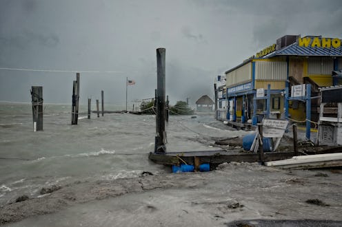
Hurricane Irma's outer bands began hitting the Florida Keys late on Saturday night, and the eye has been getting closer and closer to the islands off Florida's southern coast ever since then. As the powerful core of the storm draws nearer, anyone who chose not to obey the evacuation order has been witness to what exactly a 130 mile per hour wind looks like when it runs up against a tree, structure, or even stop sign.
Things aren't much better in Miami, where this video was shot, or elsewhere in South Florida, where extremely heavy rain has already broken previous daily rain total records and begun flooding low-lying areas. The National Weather Service has issued extremely strong warnings and guidelines for what people who didn't evacuate should do, with the number one piece of advice being, in all caps, "DON'T GO OUTSIDE." And when you see what the winds there — which aren't even the worst of what's to come — are already doing to such solid objects as stop signs, then it's pretty clear why anyone in the area should stay sheltered.
The video really puts all of those warnings into perspective, and it gives you a sense of what the hurricane categories, or the Saffir-Simpson Hurricane Wind Scale, actually mean. Hurricane Irma is currently a Category 4 storm, which according to the scale means that it will cause "catastrophic damage" to basically anything that it touches:
Well-built framed homes can sustain severe damage with loss of most of the roof structure and/or some exterior walls. Most trees will be snapped or uprooted and power poles downed. Fallen trees and power poles will isolate residential areas. Power outages will last weeks to possibly months. Most of the area will be uninhabitable for weeks or months.
Although that is quite a specific description of damage, it's difficult to imagine how it happens until you actually see how the wind manages to lay waste to basically anything that it comes into contact with, no matter how solid it seemed before the hurricane came through.
Because they're shot at night, the two videos above also give you a good sense of the lightning that's also a part of Irma. You can see the rain whipping around in the wind, but they don't show some of the most dangerous aspects of the storm, including the storm surge predicted to hit the Florida Keys and the west coast of Florida. The storm surge could reach up to 15 feet in some places, which could cover miles and miles of residential areas in the state's lowest-lying areas. For anyone who hasn't evacuated, this could be the deadliest element of the storm.
The videos taken of Hurricane Irma in the Caribbean were certainly anything but comforting, and the videos coming out of Florida now are much the same. This is truly a storm of historic proportions, and it could change the lives of tens of thousands of Floridians before it finally dissipates. These videos here are only the beginning — as the National Weather Service said, things are going to get worse before they get better. The worst part of Irma should hit the Florida Keys soon after the sun comes up, so stay tuned.
