News
This Is How Likely It Is That Hurricane Max Will Hit The U.S.
Hurricane Season 2017 has already proven one for the history books, but it's not over yet. There's a new storm that could potentially take a new path to target the same regions that were impacted by Hurricanes Harvey and Irma. Hurricane Max isn't predicted to hit the United States as of Thursday, but it's almost impossible to know for sure where the storm will land.
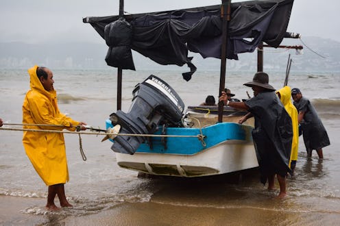
For now, the storm doesn't seem to be headed toward the United States but rather its neighbor. The Category 1 storm is forecast to hit the Mexican states of Oaxaca and Guerrero, where the National Hurricane Center warns there may be "life-threatening flooding [and] rainfall." Max is also predicted to strengthen a bit before hitting the coast, but it's not supposed to be a especially powerful or damaging storm. It's likely to dissipate altogether into a tropical depression just a few miles inland once it strikes near Acapulco.
However, there's a precedent for a storm to go right through the Mexican peninsula and hitting the Gulf Coast of the United States upon second landfall. Hurricane Andrew, which was the most expensive natural disaster in U.S. history until Katrina, blew northwest across the width of Florida and hit New Orleans after strengthening again in the Gulf of Mexico. Plus, Max is headed toward the thinnest part of Mexico, so there's a better chance that part of the system could survive long enough to reach the Gulf. It's an unlikely scenario, but given the way that things have been going lately, it's too early to count anything out.
Generally, Pacific hurricanes are a lot less common and powerful than their cousins that form in the Atlantic. According to Scientific American, one factor that helps protect western North America is the more temperate climate of the Pacific. Ocean temperatures there rarely climb above 75 degrees Fahrenheit, and hurricanes feed off of tropical-warm waters. Even when hurricanes do hit the West Coast, they're typically weakened before making landfall. In addition, the reason why Pacific hurricanes almost never hit the United States is the same reason why Atlantic ones frequently do.
"Hurricanes in the northern hemisphere form at tropical and subtropical latitudes and then tend to move toward the west-northwest. In the Atlantic, such a motion often brings the hurricane into the vicinity of the East Coast of the U.S.," Chris W. Landsea, a researcher for the National Oceanic and Atmospheric Administration, told Scientific American. "In the Northeast Pacific, the same west-northwest track carries hurricanes farther offshore, well away from the U.S. West Coast."
There's one other storm out there swirling toward land right now, as well. Hurricane Jose in the Atlantic is still a potential threat to the East Coast, though forecasters are now saying that the storm's outer bands could simply glance off the Carolinas. It's expected to turn toward the north on Saturday and run along the length of the East Coast next week, but it's still too soon to know if it will actually make landfall or just fizzle out as it moves into cooler waters.
If the nation has learned anything in the last few weeks, it should be that hurricanes are wildly unpredictable. There is simply no telling where they're going to go or how extensive the damage is going to be. That's why you're supposed to be prepared ahead of time if you live in hurricane-prone regions, so that you don't have to start stressing out until the storm is imminently upon you. It's not too late to get your supplies for this year (hurricane season technically lasts through November), or just get a jump start on your disaster preparedness kit for 2018.
