News
Objects Spotted In New Flight 370 Search Area
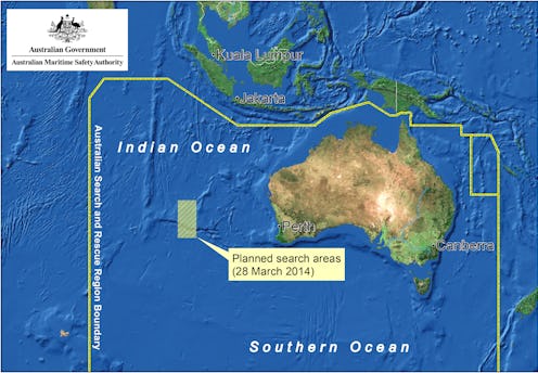
The search for missing Malaysia Airlines Flight 370 changed gears Friday, shifting nearly 700 miles northeast in the Indian Ocean based on a "new credible lead." The latest analysis of radar data shows the jetliner was traveling faster than investigators originally thought, which means more fuel was used and resulting in a lesser distance flown over the waters. Following the search's move, five of the 10 planes sent out to search for debris found floating objects, though it's unclear if these are linked to Flight 370.
In a statement Friday, Australian officials called the new information, and shift in locale, the latest lead. The search area for the Boeing 777, which vanished nearly three weeks ago with 239 people on board, has moved 680 miles northeast from where planes and ships were previously looking for possible debris. Investigators made the change based on continuing examination of radar data collected as the flight made its way between the South China Sea and the Strait of Malacca, before contact was lost.
Still, the Australian Transport Safety Bureau advised that "the potential flight path may be the subject of further refinement" as the search continues. In short: nothing is for sure, and we can expect more twists and turns in the hunt for the jetliner.
There have been no concrete links between satellite images provided and evidence of the missing plane. Friday's new developments come after a 300-object possible debris field was spotted by a Thai satellite, and 122 objects were seen in images from French officials. Australian Maritime Safety Authority tweeted that new sightings need to be confirmed by ship, which isn't expected until Saturday.
Does this mean the previous searches have been all for naught and, concentrated in the wrong area? Hishammudin Hussein, Malaysia's Defense Minister and Acting Minister of Transport, said the refined search region "could still be consistent with the potential objects identified by various satellite images over the past week" because of ocean drift.
The geographic area that's now in focus is said to be more accessible compared to the previously remote regions that were being investigated, and conditions are expected to be better. Efforts were halted twice this week due to bad weather.
