Life
What NYC Would Look Like Under 100 Feet of Water
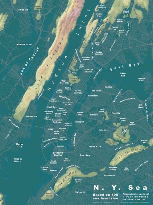
There’s nothing quite like seeing a map of your metropolitan city submerged below water to drive home the point that increased environmental consciousness is paramount to our survival. Jeffrey Linn’s map of New York City under 100 feet of sea level rise on his blog Spatialities does the trick, illustrating Lower Manhattan completely submerged, with only small patches of Upper Manhattan, Queens, and Brooklyn still accessible. His New York map is part of his ongoing cartography series that shows the impact of rising sea levels on urban environments.
Linn’s spatial modeling gives new names to neighborhoods New Yorkers know well. Sunset Park in Brooklyn becomes “Sunset Island,” and spine-chilling descriptors for former neighborhoods become “Vanished Harlem,” “Coral Gardens,” and “Yankee Aquarium,” to name but a few.
His series began when rendering a hypothetical map of what the city in which he currently lives, Seattle, might look like if all the ice caps melted. “I love cities, and I had been fascinated by some maps I'd seen that showed how various cities would be impacted by several feet of sea rise,” Linn tells Bustle. The imagery was so popular locally that his friends began reaching out with requests for maps of their own cities below sea level. “I was interested to see what happens to other places I had lived or visited, so I kept making new maps,” he says. “It's simultaneously fascinating and terrifying to see what happens to our cities at the end point of the world's ice sheets.” Emphasis on the “terrifying” bit.

For any cartography nerds, his map is available for purchase (as are his others of Montreal, Palm Springs, Vancouver, San Diego, L.A., and Portland), which you can buy here. Below, a fictional newscast of what this might look like to fuel your nightmares.
Image: Jeffrey Linn/Spatialities
