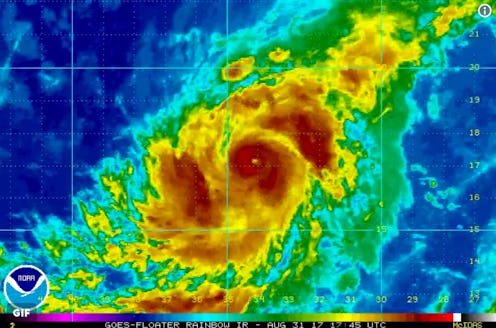
Just days after the worst of Hurricane Harvey struck southeastern Texas, weather forecasters have predicted another potential natural disaster for the United States. There appears to be uncertainty concerning its trajectory, but the latest Hurricane Irma forecast shows it heading toward the Caribbean in the next five days and could even hit the United States by next week.
At the time of writing, Irma is gaining more strength and speed, according to forecasters, while hovering over the Atlantic Ocean. Some reckon that the potential spots Irma may hit could range from Mexico to Canada.
Irma's development has been swift, forecasters say. On Wednesday morning, Irma was a simple tropical storm, but by Thursday afternoon, it had strengthened into a Category 3 hurricane carrying 115 mph winds after an increase of 35 mph within a single day. Such a powerful increment in the speed of a storm's winds is known as "rapid intensification," according to the National Hurricane Center, which has been tracking Irma's development for the past several days. The Weather Channel predicted that Irma could be headed toward Leeward Islands in the West Indies by next week but it still isn't confirmed.
As the Weather Channel noted, Hurricane Irma is currently experiencing "eyewall replacement cycle" in which a hurricane's eye undergoes a change and a new eyewall forms. For those who may not know, a storm's eyewall is essentially where its most critical and potentially devastating developments take place.
Irma's timing is remarkable. Meteorologist Evan Myers from Accuweather told USA Today that if Hurricane Irma does indeed hit the United States, it will be a historic event. "If Irma builds to a Category 4, and then hits the U.S. mainland, it will be the first time in more than 100 years the U.S. has been hit by two Category 4 hurricanes in the same year," Myers told USA Today.
According to CNN, Hurricane Irma is classified as a Cape Verde hurricane. Cape Verde hurricanes normally form in the eastern bits of the Atlantic Ocean, near the Cape Verde Islands, and then waltz over the Atlantic Ocean where their wind speeds tend to intensify at an alarming rate.
Historically, some of the most vicious hurricanes, like Hurricane Hugo and Hurricane Ivan, were categorically Cape Verde hurricanes. And that's why forecasters fear Irma at the moment. With its current position over the Atlantic, grim predictions show that Irma does not plan to calm down anytime soon.
